


Nav:HOME ---- Fishing Articles ---- All season angling in a two story fishery --looking at Lake Moomaw VA<(YOU ARE HERE)
All Season Angling in a Two-Story
Lake: Fishing Lake Moomaw VA
Nestled deep in the Aleghany Mountains
of western Virginia, sits a deep, cool, clear,lake surrounded by rolling
mountains and bluffs. Few boats and people are evident most of the
year, but there is access and camping at numerous spots. Best of all, it
holds fish wall to wall, and they can be caught any time of year! Lake
Moomaw is definitely on of the most scenic lakes I have ever visited, and
has far more in common with northern Minnesota than the Mid-Atlantic.
It is very deep, averaging over 100 feet (31m), with some points near the
dam at over 180 feet. By the way, unlike most resevoirs, it is actually
hard to find the dam from the water, as it is tucked away down one of the
many narrow branches of the lake. 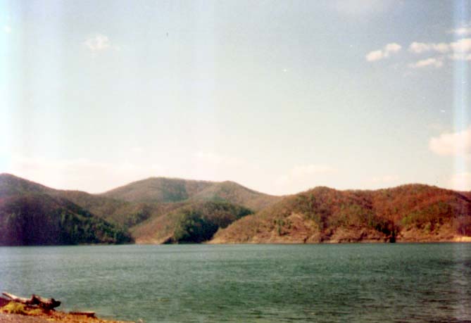 The
river that feeds this lake is the Jackson River, which hosts some excellent
brown trout fishing both above and below the lake, which eventually forms
the James River of colonial history. As an Army Corps of Engineers
impoundment, the land surrounding the lake is almost solid woods and meadows,
with occasional boat ramps, swimming areas, and picnic areas. The lake
has an excellent visitors center, and its staff will show where the 'good
spots' are at and can give you exact figures on oxygen levels, water levels,
clearity, and water temperatures. They also have free maps and helpful
brochures. For the shorebound angler, the lake is nearly totally
surrounded by public property, with steep but fishable shoreline.
There are alo several wooden piers and docks located near the boat ramps
and picnic areas. For the boat angler, I find a kayak or canoe will work
as long as the wind is not blowing hard, since the overall lake boat traffic
is low. One can drop a bass boat in at the boat ramps at Bolar Flat,
Fortney Branch, Coles Mountain, and McClintic Point.
The
river that feeds this lake is the Jackson River, which hosts some excellent
brown trout fishing both above and below the lake, which eventually forms
the James River of colonial history. As an Army Corps of Engineers
impoundment, the land surrounding the lake is almost solid woods and meadows,
with occasional boat ramps, swimming areas, and picnic areas. The lake
has an excellent visitors center, and its staff will show where the 'good
spots' are at and can give you exact figures on oxygen levels, water levels,
clearity, and water temperatures. They also have free maps and helpful
brochures. For the shorebound angler, the lake is nearly totally
surrounded by public property, with steep but fishable shoreline.
There are alo several wooden piers and docks located near the boat ramps
and picnic areas. For the boat angler, I find a kayak or canoe will work
as long as the wind is not blowing hard, since the overall lake boat traffic
is low. One can drop a bass boat in at the boat ramps at Bolar Flat,
Fortney Branch, Coles Mountain, and McClintic Point.
Due to deep water, the lake's altitude, and to intensive stocking efforts,
this lake holds both cool/cold water species and warm water species-making
it a year-round fishery with a wide variety of species to persue.
The entire gambit of sunfishes inhabit this lake: Largemouth and Smallmouth
Basses; Northern Rock Bass; Black Crappie; Redear, Bluegill, Redbreast,
and other sunfishes. The lake also hosts Brown, Rainbow (two strains), and Brook
Trout. Yellow perch provide some forage, as do alewives,
gizzard shad, chubs, and shiners. Channel catfish patrol lake,
and Chain Pickerel  round out the line-up. Just
about the only Virginia species notable absent from this resevoir are the
Striped and White basses-and that is by design. The big preditors
of this lake, in the absence of the stripers, are the
Rainbow Trout , Brown Trout, Catfish, and Largemouth Bass.
The Black basses reach into the 7 pound range, with a 5 pounder being the
smallest that will get a glance. Due to regular stocking, numerous
baby browns and rainbows (this is where they go when they can't stock the
rivers of the state) in the releasable sizes of 6"-15" inhabit the creek
mouths and journey up the Jackson on a regular basis. In the cooler
months of October-March the cold water line-up lurks near the surface,
while the warm water species go deep. In the warmer months of April-October
the water and the fish flip flop. Fall and Spring, especially when
the lake water is in 'turn over' are pandemonium-the angler is never sure
round out the line-up. Just
about the only Virginia species notable absent from this resevoir are the
Striped and White basses-and that is by design. The big preditors
of this lake, in the absence of the stripers, are the
Rainbow Trout , Brown Trout, Catfish, and Largemouth Bass.
The Black basses reach into the 7 pound range, with a 5 pounder being the
smallest that will get a glance. Due to regular stocking, numerous
baby browns and rainbows (this is where they go when they can't stock the
rivers of the state) in the releasable sizes of 6"-15" inhabit the creek
mouths and journey up the Jackson on a regular basis. In the cooler
months of October-March the cold water line-up lurks near the surface,
while the warm water species go deep. In the warmer months of April-October
the water and the fish flip flop. Fall and Spring, especially when
the lake water is in 'turn over' are pandemonium-the angler is never sure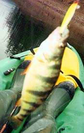 what is exactly on the other end of the line. One cast might pull
in a bass, while the next might have a trout, and yet another pickerel (locally called pike)!
Normally in the summer or winter large lakes and resevoirs stratify-the
top most layers are near the air temperature, while the deeper you go,
the warmer the water gets (winter) or the cooler it gets (summer).
A plot of the temperature looks almost like a diagonal line with a few
bumps (thermoclines). During turn-over in spring or fall as the colder
water and warmer water try to trade places, the cold and warm water mix,
and so do the fish! On most of my trips to these lakes in the fall
and spring, especially on rainy, overcast days, I troll a 4" suspending
plug in chartruese (clown) around drop-offs and edges of flats in turn-over
areas. This will get hit by just about every kind of fish in the lake.
In the summer or winter, just findout at what depth the temperature for
your favorite fish is at, and adjust accordingly. Thanks to the folks
in the visitor center, an angler need only ask one of the rangers what
depth a temeprature is at. The rangers will also tell you where turn-over
is occuring, and where the fish are at.
what is exactly on the other end of the line. One cast might pull
in a bass, while the next might have a trout, and yet another pickerel (locally called pike)!
Normally in the summer or winter large lakes and resevoirs stratify-the
top most layers are near the air temperature, while the deeper you go,
the warmer the water gets (winter) or the cooler it gets (summer).
A plot of the temperature looks almost like a diagonal line with a few
bumps (thermoclines). During turn-over in spring or fall as the colder
water and warmer water try to trade places, the cold and warm water mix,
and so do the fish! On most of my trips to these lakes in the fall
and spring, especially on rainy, overcast days, I troll a 4" suspending
plug in chartruese (clown) around drop-offs and edges of flats in turn-over
areas. This will get hit by just about every kind of fish in the lake.
In the summer or winter, just findout at what depth the temperature for
your favorite fish is at, and adjust accordingly. Thanks to the folks
in the visitor center, an angler need only ask one of the rangers what
depth a temeprature is at. The rangers will also tell you where turn-over
is occuring, and where the fish are at.
Take a trip to this lake-you won't be disapointed!
Back to Top
- When?Truely
a year-round fishery! While many rental places at the top of the lake are
closed, all the boat ramps are open (if the water is high enough).
Camping is open year round but the facilities are seasonal (March-October).
The visitor center is also open year round (follow the signs to the Dam,
then to the Visitor Center).
-
Where am I?
(Click
here for a Google Map of the Lake Moomaw Region)
Eastern United States of
America: Western Virginia (Alleghany County): Lake Moomaw Near Covington
VA and the W VA border
Driving Directions: From
the East-Take I-64 to Exit 16 (Covington VA-you will see the sign), to
hwy -220 N. After passing
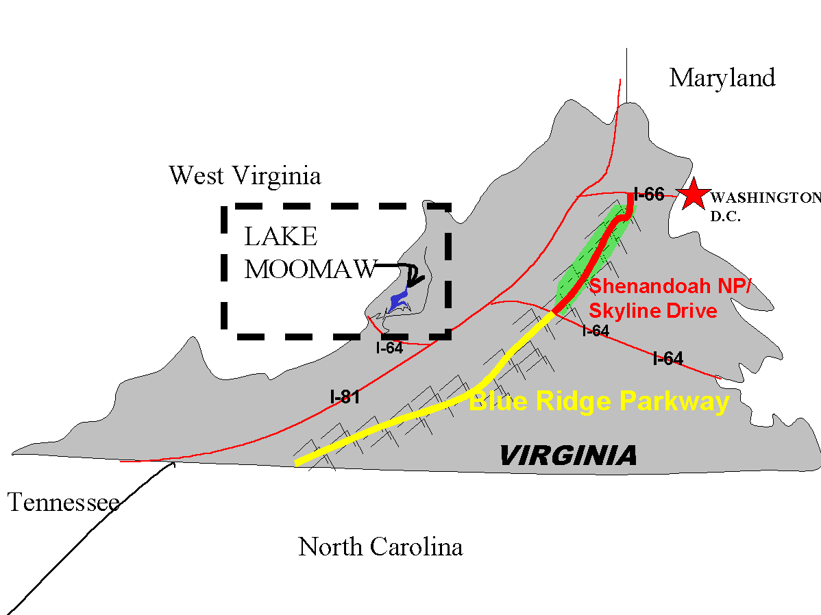 WestVaCo and a car dealership, look for the Signs to Garthright Dam. You will
make a left onto State Hwy 687 toStae hwy 641 State Hwy 666 to Hwy 605
then follow the signs to the boat ramp or dam and visitor center.
From the West: Take I-64
to exit 10 (you will see the signs to Garthright Dam), take state Hwy 159
to State Hwy 661 to State Hwy 600, follow the signs to Hwy 605, and
follow the signs to the boat ramp or dam and visitor center.
WestVaCo and a car dealership, look for the Signs to Garthright Dam. You will
make a left onto State Hwy 687 toStae hwy 641 State Hwy 666 to Hwy 605
then follow the signs to the boat ramp or dam and visitor center.
From the West: Take I-64
to exit 10 (you will see the signs to Garthright Dam), take state Hwy 159
to State Hwy 661 to State Hwy 600, follow the signs to Hwy 605, and
follow the signs to the boat ramp or dam and visitor center.
- How to catch the fish
(Tactics)?See also: Large
Lake Tactics and Lake/Pond
Ecology-Cold Water Lake (just put the big browns where
you see salmon and remove the burbot and muskelunge)RULE #1:
Go to the Visitor Center and ask the manager what the oxygen levels and
water temperatures are. They take this data almost daily and at several
location and depths. High oxygen and good water temperatures for
your favorite species will dictate where the fish are on the lake, and
how deep you will have to fish for them. Asking it from the folks
at the visitor center will save you HOURS of searching!
- How much will it cost?
Parking has a fee during the prime season (1 May-1 October). Boat rental is available near the north end of the lake
(near where the river comes into the lake)
for a variety of boats and jet skis. A basic Virginia fishing license is
a must have (you WILL be checked here). Click
here for current prices. If you fish above the lake or below
the dam on the Jackson River, you will also need a trout tag (except in
mid summer) and you will also need a Permission Slip (maybe) in the area from .5
mile below the dam to Covington, which you must write to the Virginia DGIF
to obtain. There is currenly negotions in work to remove the requirement
for the Permission Slip (maybe).
Heres the data on the fish:
-
Smallmouth Bass-Prime months are
April-June and September-November but they bite year round. During
the prime months they are shallow, while in the off months they seek 65
degree water (+/- 10 degrees) . Number one choice for prime-time is a 4"
Clown Colored floating or suspending rapala (normal or shad-rap).
Slow trolling the shorelines is deadly, as is casting to structure near
drop offs in the day time, or around rip-rap and rocks at night. In the
off prime months a 1/2oz skirted black/blue or crayfish imitating jig will
produce, as will carolina rigged lizards and worms, and 1/2oz to 1oz rattle
traps and jigging spoons (especially on the suspended winter & summer
fish). A good bass is over 4lbs here. All the usual techniques work
here in the prime seasons and they are plentiful!
-
Brown Trout- Prime months are
March-April and October-January. Available year round by fishing deep and
at night in the summer, and around river and creek mouths the rest of the
time. The small trout (under 24"-not keepers here) are easy pickings all
winter (November-April) especially during rains preceeding a cold front
near creek mouths. The big trout are another matter: trolling with 4-6"
live chubs, smelt, or alewives on a downrigger in the summer about 50 feet-80
feet down (let a 56 degree temperature curve be your guide!), or near the
surface in the winter and in the prime months at sunrise/sunset.
Lures include the aforementioned 4" rapalas (sinking or suspending) and
4" rattletraps. Also, fishing live minnows or dead shad around creek
mouths at night in the summer or at sunrise/sunset in the winter may also
produce the beasts. They get over 12lbs in this lake. An alternative
to hunting for fish in the main lake is to fish immediately below the dam
on the Jackson river (drive to the visitor center and then follow the signs
for the 'down stream access'). Just about any lure fished on 2# test
will be successful (3" sinking clown rapala or 1/8oz white crappie jig
will do), as will chicken liver (yes, I said chicken liver for trout-they
will eat it, trust me, but they also like to swallow the hook so be careful!),
an any large black/red streamer, popper (in the summer) or wolly worm (#8-#4
hook). Note: the above techniques work for the shore bound angler as well,
just focus your efforts around boat ramps near feeder creeks in the main
lake-especially Scruggs Flat.
-
Rainbow Trout- See Brown Trout
above, since they often school together when small and feed like a brown
when large.
-
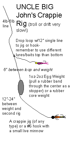
Crappie: Spring, Fall are prime,
but they are also pretty good in the summer and winter. Deep Dropoffs
w/structure. My big trick (since I don't have a depth finder)- poke with
a bank sinker until I feel the structure, since there are several downed
trees and numerous planted fish attractors like concrete slabs and old
tires, until I feel the spot- ususally in 10-20 feet of water in summer
and 30 feet in winter. Then I drop a 1/8-1/16oz chartruese or white
roadrunner onto the structure and work it back to the surface with a steady,slow
jigging motion. The boat ramps on the east side of the lake (the
one near the swimming area is a good example) have many of these manmade
fish attractors at the right depth when the water is high in the spring.
Look also for channel markers and 'no wake' bouys, since they are anchored
with concrete hunks and often have structure around them, and are eay to
cast to from the shoreline. All the standard crappie trolling techniques
will work if you focus on the rocky dropoffs with a 30 degree-60 degree
slope (slow troll using my Uncle
'Big' John's favorite crappie rig) The bottom of some of the
bluffs my be productive but I haven't tested this one yet. In the late
spring overhanging bushes and trees over deep water (especially with sack
worms in the tree or bush) can payoff for someone willing to use a 5wgt
flyrod to toss a #10 yellow/black wolly worm on a 2lb tippet under the
bush- the shore angler is best suited for this one. A sack worm on
a #12 hook with no weight or bobber and on 2lb test will also work.
-
Yellow Perch: Fall, Summer, Spring-
On-comming cold fronts (the calm, foggy, overcast rainy days) of the fall
and spring during water 'turn over' are killer for the big Yellow perch.
When the water is in the high 50's-low 60's on shallow flat, rocky, areas
they school and assault nearly any 3" sized minnow imitating lure on light
line (exactly how the one pictured up top was caught). They will
also hit mealworms, red worms (the little earthworms), and small live minnows
fished freelined in fallen trees on light line (4# or less) with #8-#10
hooks(yes-you will lose a couple hooks this way but it will pay off).
Many of the crappie techniques above and most bluegill and sunfish techniques
will also payoff for these fish.
-
Chain Pickerel:
Spring/Fall-Most my catches on these guys (native pre-impoundment)
have been incidental to chasing the trout or bass. They like bad
weather and structure, and they will follow the schools of small trout
and yellow perch into shallow creek mouths, flats, and bays. They
can also be seen smacking the surface in these shallow areas-making them
an easy target for a floating lipped plug in the 4"-6" range retrieved
with alot of motion (jerk and pull). Make the plug look like an injured
Yellow perch (the reason why the clown colored rapalas are so effective
here) or trout floundering near the surface and they will wack it hard.
They are also found in the same areas that the largemouth hang out below.
P.S. mono leaders will catch far more fish that steel leaders - but be
prepared to lose an occasional plug or twitchbait. Shad colored 3 inch soft plastics work well also.
-
Largemouth Bass: Summer/early
fall are best here-Shallow bays with dead trees, especially with
nearby deep water, are regular payoff spots for these guys in the early
morning or early evening. They are well outnumbered in this lake
by smallmouth bass, but do grow very big if they can get big enough to
eat the little trout. 4" clown rapala among numerous other lures
(creyfish imitating jigs, floating worms, bass assasins, rattle traps,
spinner baits, etc.) will get numbers of fish. I have yet to get
one of the big boy bass out of this lake, but as soon as I locate a 8"
plug in rainbow trout pattern I will put the little trout theory to the
test.
-
Catfish: Summer is best- all the
standard channel cat techniques payoff, though this is by far a best game
played at night on the surface with bobbers near structure. The cool
water in this lake puts the cats near the surface at night in the summer,
and deep in the winter. Dead shad, live minnows will work here, and may
payoff with a trout or pike if you are lucky.
-
Brook Trout- Three locales but
they are very difficult to target here: Creek mouths (spring/fall), rocky
drop-offs (fall/winter). Smaller suspending and sinking plugs and
2" rattle traps will put you in their range, but most likely you will pick
off just about every other species before you get one of these.
Back to
Top
Back to Top
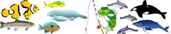
Some Fishes you might see:
Back to Top
Latest Reports |
Fishing Articles |
Fishing Tactics |
Fish Ecology and Biology |
Travel Articles |
Fishy Fun |
External Links |
Shopping |
HOME
LEGAL: ALL content ©1993-2015 Bryce L. Meyer. The term "Combat-Fishing" is a federally registered trademark. "Combat Fishing" when used in reference to travel information, fishing websites, fishing or travel books, or similar products as a brand is also a trademark. Fish and Pole logo is also a trademark.